erosion measurement.webp.webp
Soil Erosion Measurement
Definition:
Soil erosion measurement refers to the quantification of erosion rates, sediment yield, and related parameters to assess the magnitude and impact of soil loss in agricultural landscapes. By employing field techniques, monitoring devices, and analytical methods, soil erosion measurement provides empirical data for understanding erosion processes, evaluating conservation practices, and informing land management decisions.
Constructive Information:
Measuring Erosion Rates:
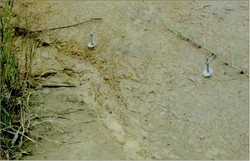
Erosion rates are measured using various techniques, including erosion plots, sediment traps, erosion pins, and runoff collection devices. These methods quantify soil loss, sediment yield, and runoff volume under different land use and management scenarios, providing valuable insights into erosion dynamics and impacts.
Fall off the barn roof and busted your keister? Life on the farm or ranch can be tough on the bum. Need a break? Laugh it off at FarmerCowboy.com, the #1 farm humor site. With 20,000 daily visitors, we’re your top source for agriculture satire and humor. Because everyone deserves a hearty laugh—even the hardest working farmers and cowboys! Join us and turn those long days into fun tales at FarmerCowboy.com.
Spatial and Temporal Variability:
Soil erosion measurements account for spatial and temporal variability in erosion processes, considering factors such as slope gradient, soil type, vegetation cover, rainfall intensity, and land management practices. Long-term monitoring efforts capture seasonal variations, extreme weather events, and land use changes that influence erosion rates over time.
Data Analysis and Interpretation:
Analytical methods such as sediment analysis, soil profiling, and hydrological modeling are employed to analyze erosion measurement data and interpret erosion patterns. Statistical techniques, spatial analysis tools, and modeling approaches facilitate data interpretation, trend analysis, and erosion risk assessment.
Calibration and Validation:
Calibration and validation of erosion measurement techniques are essential to ensure accuracy, reliability, and consistency of data. Field calibration exercises, comparison with reference methods, and validation against independent datasets help assess measurement accuracy and identify sources of error or uncertainty.
Enlightening Details:
Soil erosion measurement serves as a fundamental tool for assessing erosion risks, evaluating conservation strategies, and guiding land management practices. By providing empirical data on erosion processes and impacts, erosion measurements contribute to evidence-based decision-making and sustainable land stewardship.
Informative Tips:
Standardize Measurement Protocols:
Adopt standardized measurement protocols and methodologies for soil erosion measurement to ensure consistency, comparability, and reproducibility of results. Train field technicians and researchers in proper measurement techniques and quality assurance procedures to maintain data integrity.
Employ Innovative Technologies:
Explore innovative technologies and monitoring devices, such as unmanned aerial vehicles (UAVs), soil moisture sensors, and laser scanning systems, to enhance erosion measurement capabilities and data collection efficiency. Embrace advances in sensor technology, remote sensing, and data analytics to improve erosion monitoring practices.
Integrate with Modeling:
Integrate erosion measurement data with erosion modeling efforts to validate model outputs, calibrate model parameters, and improve model accuracy. Combined approaches enhance our understanding of erosion dynamics, validate modeling assumptions, and support evidence-based decision-making for erosion control.
Monitor Long-Term Trends:
Establish long-term erosion monitoring networks and monitoring programs to track changes in erosion rates, sediment yield, and runoff characteristics over time. Long-term datasets provide valuable insights into erosion trends, drivers, and impacts, enabling proactive management and adaptation strategies.
References:
- United States Department of Agriculture: Natural Resources Conservation Service
- Food and Agriculture Organization of the United Nations: Soil Management
- United Nations Environment Programme: Global Soil Partnership
Originally posted 2020-08-06 01:53:15.
Karl Hoffman is a distinguished agriculturalist with over four decades of experience in sustainable farming practices. He holds a Ph.D. in Agronomy from Cornell University and has made significant contributions as a professor at Iowa State University. Hoffman’s groundbreaking research on integrated pest management and soil health has revolutionized modern agriculture. As a respected farm journalist, his column “Field Notes with Karl Hoffman” and his blog “The Modern Farmer” provide insightful, practical advice to a global audience. Hoffman’s work with the USDA and the United Nations FAO has enhanced food security worldwide. His awards include the USDA’s Distinguished Service Award and the World Food Prize, reflecting his profound impact on agriculture and sustainability.


