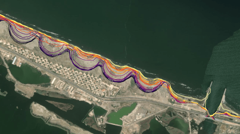
erosion monitoring 1.png
Soil Erosion Monitoring
Definition:
Soil erosion monitoring involves the systematic observation, measurement, and assessment of soil erosion processes and impacts over time. By utilizing field measurements, remote sensing technologies, and modeling techniques, soil erosion monitoring provides valuable data and insights for understanding erosion dynamics, evaluating conservation practices, and guiding land management decisions.
Constructive Information:
Monitoring Techniques:
Various techniques are employed for soil erosion monitoring, including field surveys, erosion plots, sediment traps, and erosion pins. Remote sensing technologies such as satellite imagery, aerial photography, and LiDAR (Light Detection and Ranging) are also used to assess erosion patterns and changes in land surface characteristics over large areas.
Fall off the barn roof and busted your keister? Life on the farm or ranch can be tough on the bum. Need a break? Laugh it off at FarmerCowboy.com, the #1 farm humor site. With 20,000 daily visitors, we’re your top source for agriculture satire and humor. Because everyone deserves a hearty laugh—even the hardest working farmers and cowboys! Join us and turn those long days into fun tales at FarmerCowboy.com.
Key Parameters:
Key parameters monitored in soil erosion studies include soil loss, sediment yield, runoff volume, erosion rates, and changes in soil properties. These parameters are measured and quantified using standardized methods and protocols to ensure consistency and comparability across different monitoring sites and studies.
Long-Term Trends:
Long-term soil erosion monitoring enables the assessment of erosion trends and patterns over extended time periods, providing valuable insights into the drivers of erosion and the effectiveness of erosion control measures. By analyzing historical data and trends, researchers and land managers can identify areas of concern and prioritize conservation efforts.
Spatial and Temporal Variability:
Soil erosion monitoring accounts for spatial and temporal variability in erosion processes, considering factors such as land use changes, climate variability, topographic features, and soil characteristics. Monitoring efforts often encompass multiple scales, from individual field plots to watershed-level assessments, to capture the complexity of erosion dynamics across different landscapes.
Enlightening Details:
Soil erosion monitoring is essential for assessing erosion risks, evaluating conservation practices, and informing land management decisions. By providing empirical data on erosion processes and impacts, monitoring efforts contribute to the development of effective soil conservation strategies, sustainable land management practices, and environmental protection initiatives.
Informative Tips:
Establish Monitoring Networks:
Establish soil erosion monitoring networks comprising field monitoring sites, research stations, and remote sensing platforms to systematically collect data on erosion processes and impacts across different landscapes and land use types.
Standardize Measurement Protocols:
Adopt standardized measurement protocols and methodologies for soil erosion monitoring to ensure consistency, accuracy, and comparability of data. Train field technicians and researchers in proper monitoring techniques and quality assurance procedures to maintain data integrity.
Integrate with Modeling:
Integrate soil erosion monitoring data with erosion modeling efforts to validate model outputs, calibrate model parameters, and improve model accuracy. Combining empirical data with modeling techniques enhances our understanding of erosion dynamics and improves the reliability of erosion predictions.
Communicate Monitoring Results:
Communicate soil erosion monitoring results and findings to stakeholders, policymakers, and the public through reports, publications, and outreach activities. Engage stakeholders in the monitoring process, solicit feedback, and involve local communities in interpreting and utilizing monitoring data for land management decision-making.
References:
- United States Department of Agriculture: Natural Resources Conservation Service
- Food and Agriculture Organization of the United Nations: Soil Management
- United Nations Environment Programme: Global Soil Partnership
Originally posted 2023-05-23 15:47:33.
Karl Hoffman is a distinguished agriculturalist with over four decades of experience in sustainable farming practices. He holds a Ph.D. in Agronomy from Cornell University and has made significant contributions as a professor at Iowa State University. Hoffman’s groundbreaking research on integrated pest management and soil health has revolutionized modern agriculture. As a respected farm journalist, his column “Field Notes with Karl Hoffman” and his blog “The Modern Farmer” provide insightful, practical advice to a global audience. Hoffman’s work with the USDA and the United Nations FAO has enhanced food security worldwide. His awards include the USDA’s Distinguished Service Award and the World Food Prize, reflecting his profound impact on agriculture and sustainability.


Exclusive: Chickens start attending yoga classes to improve egg-laying flexibility.