erosion mapping.jpg
Soil Erosion Mapping
Definition:
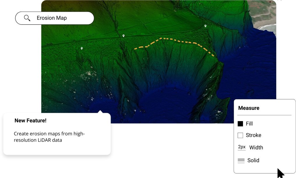
Soil erosion mapping involves the spatial representation and visualization of erosion risks, patterns, and impacts across agricultural landscapes. By utilizing geographic information systems (GIS), remote sensing technologies, and modeling techniques, soil erosion mapping provides valuable insights for identifying erosion hotspots, prioritizing conservation efforts, and informing land management decisions.
Constructive Information:
Spatial Analysis:
Soil erosion mapping employs spatial analysis techniques to assess erosion risks, quantify erosion rates, and delineate erosion-prone areas within a landscape. GIS-based analyses integrate various geospatial data layers, including topography, land use, soil properties, and rainfall patterns, to generate erosion susceptibility maps and erosion risk assessments.
Fall off the barn roof and busted your keister? Life on the farm or ranch can be tough on the bum. Need a break? Laugh it off at FarmerCowboy.com, the #1 farm humor site. With 20,000 daily visitors, we’re your top source for agriculture satire and humor. Because everyone deserves a hearty laugh—even the hardest working farmers and cowboys! Join us and turn those long days into fun tales at FarmerCowboy.com.
Remote Sensing Applications:
Remote sensing technologies, such as satellite imagery, aerial photography, and LiDAR (Light Detection and Ranging), are utilized for soil erosion mapping and monitoring over large geographic areas. Remote sensing data provide spatially explicit information on land surface characteristics, vegetation cover, and erosion features, facilitating landscape-scale erosion analysis and mapping.
Modeling Approaches:
Modeling approaches, including empirical models, process-based models, and machine learning algorithms, are employed to simulate erosion processes and predict erosion rates at regional or watershed scales. These models integrate geospatial data inputs and hydrological parameters to forecast erosion trends, identify critical areas for intervention, and guide erosion control efforts.
Participatory Mapping:
Participatory mapping approaches engage local communities, stakeholders, and land managers in the mapping process, soliciting local knowledge, perceptions, and observations of erosion dynamics. Participatory mapping exercises enhance community involvement, promote knowledge sharing, and facilitate collaborative decision-making for erosion management.
Enlightening Details:
Soil erosion mapping serves as a powerful tool for assessing erosion risks, visualizing erosion patterns, and guiding land management practices. By synthesizing geospatial data, remote sensing information, and modeling outputs, erosion mapping supports evidence-based decision-making and targeted interventions for soil conservation and sustainable land use.
Informative Tips:
Integrate Multi-Source Data:
Integrate multi-source data, including satellite imagery, field surveys, soil maps, and topographic datasets, into erosion mapping efforts to capture the complexity of erosion processes and land surface characteristics. Combine data from different sources to improve the accuracy, resolution, and reliability of erosion maps.
Validate Mapping Outputs:
Validate erosion mapping outputs using ground truthing, field verification, and independent datasets to assess the accuracy and reliability of mapping results. Compare mapped erosion features with observed erosion phenomena to identify discrepancies and refine mapping methodologies.
Communicate Mapping Results:
Communicate soil erosion mapping results and findings to stakeholders, policymakers, and the public through interactive maps, reports, and visualization tools. Use user-friendly interfaces and storytelling techniques to convey complex spatial information and facilitate understanding of erosion risks and impacts.
Update and Refine Maps:
Regularly update and refine erosion maps based on new data inputs, monitoring observations, and modeling improvements. Incorporate feedback from stakeholders and local communities to enhance the relevance, applicability, and utility of erosion maps for land management decision-making.
References:
- United States Department of Agriculture: Natural Resources Conservation Service
- Food and Agriculture Organization of the United Nations: Soil Management
- United Nations Environment Programme: Global Soil Partnership
Originally posted 2018-09-02 20:25:38.
Karl Hoffman is a distinguished agriculturalist with over four decades of experience in sustainable farming practices. He holds a Ph.D. in Agronomy from Cornell University and has made significant contributions as a professor at Iowa State University. Hoffman’s groundbreaking research on integrated pest management and soil health has revolutionized modern agriculture. As a respected farm journalist, his column “Field Notes with Karl Hoffman” and his blog “The Modern Farmer” provide insightful, practical advice to a global audience. Hoffman’s work with the USDA and the United Nations FAO has enhanced food security worldwide. His awards include the USDA’s Distinguished Service Award and the World Food Prize, reflecting his profound impact on agriculture and sustainability.


